Categories
Advocacy/Awareness Bikepacking

Idaho Conservation League Benefit Event at Smoke ‘n’ Fire Riders’ Meeting

Holy Smokes! We’re one week out from the Grand Depart and the 2017 Smoke ‘n’ Fire 400 has already lived up to its name!  Despite the smoky haze, we hope you’ll join us at the riders’ meeting on Tuesday the 12th for a special event benefiting the Idaho Conservation League!
 
We’ll pour beverages for a suggested donation of $4/pint and sell raffle tickets for $5/ea or $20/5, so BRING CASH!  100% of proceeds will benefit the ICL and their work protecting Idaho’s priceless land, air, water and wildlife.  Highlands Hollow is providing a keg of delicious brew and the raffle is stacked with products from Surly, Revelate, Sinewave Cycles and more!
 
You don’t need to be a Smoke ‘n’ Fire rider to participate, so bring your family and friends for a celebration of human-powered adventure and natural resource conservation!
  • Tuesday, September 12, 6pm, Sun Ray Cafe (1602 N. 13th St)

  • RSVP and find more info on the Facebook event page here.

  • BRING CASH!

Categories
Advocacy/Awareness

#OptOutsideBTN Instagram Photo Contest!

It is coming.  You can practically smell the monster’s rancid breath as it approaches.  Retailers and “consumers” across the country will soon be in its grip.  Poor, helpless employees will be struggling for survival like citizens of Tokyo hoping to escape Godzilla’s rampage.  Of course, the monster I’m describing is the annual shopping blitz known as Black Friday.

However, there is a way out.  In fact, it is easier than you might think!  Don’t go shopping.  Go outside, ride your bike and enjoy the world outside the fluorescent-lit halls of consumption.  You don’t really want to be a “consumer” anyway, do you?

Bike Touring News will Opt Outside on Friday, November 25 and we want you to join us!  To encourage you to join in, we’re holding the first-ever

#OptOutsideBTN Instagram Photo Contest!

 You can win great prizes, have some fun and share in the adventure with Instagram users all over the world.

Read on to learn how to participate!

p1190930

How to Enter:

Post a photo to Instagram during the contest period showing your adventurous outdoor pursuit (preferably involving a bicycle) using the hashtag #OptOutsideBTN.  Entries must be properly tagged to be valid!  Multiple entries are encouraged, so post away!  See the Judging Criteria below for some guidelines.

Timeline:  

The contest runs from 12am, MST on Wed. 11/23 through midnight on Sunday 11/27.  Winner announced on 11/29.

Prizes:  

Grand Prize – Surly Merino Hoody in winner’s choice of size and color!  ($180 value!)  This is an awesome layering piece that is perfect for everyday wear on or off the bike.  Available in Men’s and Women’s sizing.  Follow the links to learn more or view size charts.

Runner-Up – BTN Water Bottle stuffed with winner’s choice of Nuun drink tablet flavor, Surly t-shirt and Socks! (~$60 value!)

NOTE: Color and size options may be limited due to availability.

Judging Criteria:

  • Adventurousness – We want to see you get out and explore your world by bike!
  • Originality – Go where few have gone before and show us your unique perspective.
  • Timeliness – We don’t want to see your ride from last month!  Keep it fresh and current.
  • Humor – Make ‘em laugh!  Clever captions and hashtags help here.
  • Composition – Don’t forget that Instagram uses the square format!
  • Use of the Bicycle – You don’t have to incorporate your bike to win but it’ll sure help!

Terms and Conditions:

The Grand Prize Winner and Runner Up will be chosen by a panel of impartial judges.  Owners, employees or other agents of Bike Touring News will not participate or influence judging.  The Judges’ decision shall be final and binding.

No preference will be given to Bike Touring News customers and no purchase is necessary to win.  Purchasing will not increase the likelihood of winning.  Owners, employees or other agents of Bike Touring News and their families are not eligible to win.  They’re still welcome to post their photos, however!

By using the #OptOutsideBTN hashtag you give Bike Touring News permission to use your tagged photo(s) in any manner, including reposting to other social media outlets, use in promotional content and any other lawful use.

Winners will be notified via public Instagram post and direct message.  Prizes may be claimed in person at Bike Touring News in Boise, ID or shipped to the winner’s address.  Bike Touring News will cover shipping costs to addresses in the USA.  International winners must pay shipping to receive their prize and may be liable for duties, taxes or other import fees.

p1200201

So get out there, have an adventure, take a picture and share your story!  We’re looking forward to sharing in the journey with you!

Categories
Advocacy/Awareness Bike Touring Tips

Braving the Elements – biking in wet conditions

Don't forget to smile!
Don’t forget to smile!

Much laughter was exchanged on a recent S24O as we watched the clouds roll in and the rain begin to fall and one of our friends said “but the forecast said no rain until late tomorrow”.  The smug ones in the group put on our jackets, the others just rode faster :).  We’ve all been guilty of thinking off thinking; “nah, I don’t need (your missing item here)”.

In all seriousness, I write this as the days grow shorter and the weather starts to turn so I thought I’d create a check list of a few tips, must haves and some quick substitutes.

It’s raining – SLOW DOWN – BE AWARE – PAY ATTENTION

  1. Brake early and slowly. If the temperature is dropping, chances are small particle of ice are forming – ever slipped on black ice? It isn’t fun. Rim brakes will be contacting with wet rims, taking longer to stop.  Disc brakes might not be as affected but be prepared just the same.
  2. Turn on your lights – if you don’t have lights on your bike, you shouldn’t be riding a bike (we don’t claim to be neutral on this one)  Be visible. It’s grey and you will be less visible to motorists. The brighter you are the better.
  3. Pay attention to the road – puddles can hide metal grates and submerged plant debris plus you can’t always tell how deep they are or if a pothole lurks beneath.  Piles of wet leaves can be like hitting a patch of ice.  Sliding off a wet man hole cover or a slick railroad track makes for a hard landing. Don’t hug the curb, take the lane and go around the debris collecting in the gutter.
  4. Be extra alert.  Even if you are in Idaho, with it’s unique “Idaho stop” laws, stop at the stop sign and the red light, make eye contact with drivers.  As much as you want to, don’t tuck you chin down into the big hood you just pulled over your helmet – keep looking around.
  5. Again, slow down so if something unexpected pops up you can react.

Gear Up

  1.  Fenders – We are year round fender people and think touring bikes and commuting bikes without fenders just look naked.  Fenders not only keep your rear end and feet dry, they protect your bike from grit and grime. Investing in a solid pair makes a huge difference.  Plus it gives you another place for a tail light – sweet!
  • Not much comes to mind as a substitute for fenders. If you have racks, placing a piece of card board on the top of the rack will help and then put some plastic bags on your feet before you put them in your shoes.

2.  A decent rain jacket – buy once, cry once.  Invest in a breathable jacket that covers your tush. Zippered vents or zip off arms are awesome too.  Then take it with you, even if the weather forecast doesn’t call for rain.

  • Rain jacket still in the closet? Stop somewhere and beg for a plastic garbage bag, punch some holes for your arms and head and while you at it, get two small bags for your feet. If you are lucky stop at the dollar store and get a cheap poncho – you’ll be flapping but hopefully will stave off hypothermia.

3.  Waterproof Pants – There are fancy and not so fancy rain pants.  Some folks use the same pant they have for backpacking and carry a pant leg strap to keep them from catching the chain rings.  Make sure they fit well over your bike shorts or street clothes and fit under your rain jacket.  A pair with zippers and hook and loop closures on the bottom are great, making it easier to take on and off without having to remove your shoes.

  • Years ago we didn’t own rain pants but instead took some rain chaps we must of had from backpacking.  We did a week long trip and it poured every single day… Let’s say the chaps went into the trash before we even packed the bikes for home.  I haven’t seen it done but am sure one could get creative with garbage sacks.

4.  Booties or shoe covers – just make sure you get the size that fits over your shoe.  Road shoe covers don’t like MTB shoes.  Some shoe covers are just for rain, others are heavier for more warmth.

  • Okay, I have been known to slide my feet into plastic sacks on more than one occasion.  I also know someone who fashioned paper cups over the toes on a particularly cold and windy ride.

5.  Something on your head – Personally I (Sky King) like a helmet cover but the Bike Hermit likes a skull cap under his helmet.  We also know riders who have hoods on their riding rain jackets so the water doesn’t run down the neck. I still believe, a large chunk of heat loss is via your noggin so keep it covered when it’s cold and wet.

  • Something we never ride without is a bandanna, they can easily give light cover under a helmet in the rain.  As mentioned, a hood on the jacket – as long as you can still see.  The bike hermit actual owns a shower cap he uses as a saddle protection cover and a dollar store shower cap over your helmet or under you helmet would keep you head dry and be a good conversation starter.

6.  Full Fingered Gloves – Options galore here and  don’t rule out equestrian gloves – like bike gloves, they are meant to fit snug and tend to be less expensive than biking gloves.

  • Water proof gloves? We live in the high desert so ours tend to be insulated but not 100% water proof. Some of the “lobster” gloves which are sort of a cross between a glove and a mitten are extremely warm, the ones made of neoprene being almost too warm in many conditions.  Given all that, when it’s calling for wet and chilly, I pack two pairs of gloves.  Haven’t seen this yet but a dollar store pair of rubber gloves with a dollar store pair of one size fits all gloves would sure be toasty! (I may have to invest in that as my back up set).  In a real pinch take that trusty bandanna and split it in two and fashion some coverage – better than a poke in the eye with a sharp stick.

7.  Chemical foot and hand warmers – we buy these by the case.  Actually we just buy the foot ones as they also work for hands.  Come fall, a set lives in my front bag.

  • if it’s that cold a good flask of whiskey and a thermos of coffee seems like a plan to me.

8.  Reflective Bits –  anything to be more visible.  In today’s market there is reflective tape, reflective spoke covers, reflective vests – it’s cheap, just do it.

9. Something to wipe your glasses off with – now a defogging cloth is probably smart but again, having my bandanna I can dry my glasses, wipe my nose and cover my head.  I just have to remember which corner is for which purpose.

10.  Saddle covers – of course when you are riding your saddle is covered… We use ours for stops and for camping.  I love my Gilles Berthoud cover.  Brooks also makes one.

  • this is an easy thing to find a substitute for – we’ve all seen or used the plastic grocery bag.  The Bike Hermit’s shower cap is great and who hasn’t taken one of their panniers or dry bags and plopped it over their saddle at camp to keep off the rain, snow or dew.

So don’t let a little unsettled weather keep you from using the bike. Some of our most memorable rides have been riding home after dark in the rain on the multi-use-path. As someone who lives in Portland, OR might say when asked how they can ride in the rain ; “Just keep pedaling”

Categories
Advocacy/Awareness Idaho Our Trips Tours and Rides

Riding The Weiser River Trail

Early last year, a friend of mine (who happens to live in Weiser) mentioned the existence of the Weiser River Trail. I had never heard of it, so I went online to check it out. (Mash here for the main web site. There is also info at the National Recreation Trails site, and the Rails-to-Trails Conservancy)

So, in mid-June of last year, my wife and I and two friends decide to check it out, so we drove out to Weiser and took a short spin on the lower part of the trail, beginning at the Weiser trailhead, which is located a few blocks east of US 95 on Main Street in a residential area. It took us just over an hour to get to Weiser from Boise.

It was a nice jaunt, made tolerable by overcast skies and cooler temps. This part of the trail wends its way through a valley that is mostly farmland. It’s flat and open, but scenic. We rode to the canyon mouth near Galloway Dam and the Presley trailhead, where the trail turns north from its formerly east/west alignment, then turned around and headed back. The round trip was about 16 miles.

Vehicle access to the Presley trailhead is via Weiser River Road. If you turn east on Park St., which is the only traffic light on US 95 in Weiser, it turns into Weiser River Road near the edge of town.

Our initial impressions of the trail were that it was uncrowded, there is very little shade along the way, and it’s pretty rough in spots. Being a Rails-to-Trails conversion, there was still plenty of railroad ballast on the roadway. It mostly consists of what looks like 2” crushers. You definitely want larger, softer tires on this trail.

This year, we decided to tackle the trail again, and try out different sections, as it was reported to us by some locals we met at the Weiser trailhead that the trail conditions improve as you travel further north. Of course, we met them AFTER we just finished our ride, so it was too late to move on up the road to another location. Lunch and liquid refreshment were the order of day at that point.

Memorial Weekend 2016 – Weiser to Thousand Springs Creek

I somehow convinced my son to join me on a camping trip on the trail. Paying for the requisite improvements to his bike (thanks, Jim!) probably didn’t hurt. We loaded up our gear on Saturday morning and headed out with high hopes. My friend who lives in Weiser agreed to let us leave our car in the street by his house, so it wouldn’t be sitting at a trailhead for multiple days (what can I say, I’m paranoid). This added another 2 miles to the ride at either end, but we got a scenic tour of the town of Weiser that way.

We got on the way shortly after noon, and after a couple miles on the trail we decided to cut over to Weiser River Road for a smoother paved road ride, so as to stave off saddle soreness as long as possible. We did encounter some interesting-looking local fauna on that leg of the trip, too.

(Note strategic placement of thumb shifter in photo. Composition is everything!)

We rejoined the trail at Galloway Dam and carried on from there. From this point, all the way to our campsite and back to the dam the next day, we never saw anyone else on the trail. We did encounter a group of kayakers who told us about the campsite we stayed at (“..it’s only a few miles up the trail!”), and they mentioned that they had ridden the trail the previous weekend when it was a muddy mess from a recent storm. They indicated that they liked it that way, too.

One thing about this whole leg was that there wasn’t much in the way of easy access to the river. I was carrying a Katadyn filter and towards the later part of the afternoon I was starting to wonder when I might be able to refill our water bottles. Fortunately we encountered our campsite shortly after, and it included a small beach where you could pump water pretty easily.

The campsite is improved, and is in a small section of BLM land. It includes a fire pit, picnic table, bench, and a porta potty a short ways down the road (so you don’t have to smell it). It is located at Thousand Springs Creek.

Looking north

Looking south

Here we spent an uneventful, if slightly uncomfortable, night. This was mostly due to not having super nice sleeping pads, but it was also pretty windy and noisy all night long.

The next morning we got up, had breakfast, packed up, and headed back. We might have gone further if we felt more rested, but the slow going (for us) road conditions and a late-ish start the previous day convinced us to call it a trip at that point. I had hoped to get to Midvale the first day, but we didn’t quite make it. That’s about ten miles further along.

The butte on the other side of the river the next morning, to the NE of the bridge. We saw some goats grazing on the hillside the previous evening, along with a fox that took off like a flash when it spotted us.

Taylor fiddling with something on his bike prior to departing.

If you like this kind of scenery, the Weiser River Trail has oodles of it!

Taking advantage of a rare spot of shade for a snack and a drink.

No strollers or roller-bladers here! Eat your heart out, Boise Greenbelt. Taylor is up ahead doing his Roadrunner impersonation. Meep! Meep! (We used to live in NM, so we know that roadrunners don’t actually run very fast.)

Midvale to Cambridge, June 19th (Father’s Day)

Leesa and I decided to be anti-social and head out on a fine Father’s Day Sunday for another section of the trail. This section features more farmland, and a short but interesting part that goes through a canyon right before you arrive in the thriving metropolis of Cambridge.

The trail conditions along here are better than the southernmost section, for the most part. It’s still a dirt trail, no matter how you slice it.

The trailhead at Midvale is at a nice shady park with water and a porta-potty. There’s a nice restaurant at the south end of town, too (about 200 yards from the trailhead – Midvale is not very big).

The round-trip distance worked out to about 18 miles.

We saw two does, or we saw this one twice. We also saw a really nice 4 point buck just south of Cambridge, but he ran off before we could take a picture of him.

Leesa having a rest in the shade at Cambridge.

Looking south from Cambridge trailhead. The Washington County fairgrounds are on the left. Leesa is the pink speck.

Just south of Cambridge looking south, just before the canyon.

Out in the farm country between Cambridge and Midvale.

Evergreen Campground trailhead to Tamarack (July 17th)

Wanting to see some different scenery, we opted to take a trip up into the mountains and ride the top section of the trail. There is a trailhead inside the Evergreen campground, which is up in the mountains a short ways from Council on US 95 – maybe 20 minutes drive time. The main trailhead at the northern terminus of the trail is at Tamarack, but the trail extends a short ways further from there. The Tamarack trailhead is located off to the east side of 95 just slightly north of the lumber mill. There is a road going into a meadow, and the trailhead parking area is back about 3/8 of a mile and features lots of parking, horse thingies, a pit toilet, water, and a picnic table.

We parked at Evergreen and rode up to Tamarack and back down, which is about a 13 mile round trip. There is some climbing on this section (beyond the 2% grade that you’re already climbing), especially right near the lumber mill. There is a lovely spot there with some steep switchbacks which are covered generously with loose gravel. Going up isn’t a problem, but coming down requires a steady hand.

This part of the trail is smoother than some of the more desert-like sections, and has more shade, since you’re up in the mountains.

Unfortunately, we left the camera in the car that day, so we don’t have any pictures from this segment.

Council to Fruitvale (August 6th)

This was supposed to be Council to Evergreen, but the weather forecast for Council was way off on the web (thanks, Intellicast!), so we had to cut it short due to high temperatures. It’s too bad, because just past Fruitvale the trail takes some serious bends and then heads up into the hills. We’ll catch that section some other time.

The Council trailhead is easy to get to. Just turn left in downtown Council right where the highway takes a hard right turn, and just follow that road as it winds to the right. The trailhead is easily visible just up on the left, and features a covered table and a porta potty cleverly hidden behind a storage shed on the other side of the road. If you head north on the trail, you will see it on the right.

This section was pretty much farmland, but did have lots of apple trees and huckleberries growing right along the trail. (The apples were definitely all “organic,” if you know what I mean.) The trail mostly runs straight right through to Fruitvale.

Just south of Fruitvale, looking north. Much of the visible shrubbery along the trail right here has fruit on it.

A hot and tired Leesa, ready for a ride in an air-conditioned car. Note the shed in the background – the porta potty is right behind it.

We haven’t been on the Cambridge to Council section but apparently there is a hot springs along there. After riding in 95 degree weather, a soak in hot water didn’t sound all that great, but later in the year it might be much more appealing.

To Sum Up, and some random blathering about printed materials

The Weiser River Trail is a nice change of pace and scenery from some other local trails, like the Boise Greenbelt. It’s close enough to get to with a relatively short drive (relative to driving up to Coeur d’Alene, for example), but far enough and unknown enough to provide some solitude while out riding. It’s also long enough to provide multiple opportunities to ride it without seeing the same thing twice, unless you just have to do the whole thing all at once. The other nice thing is that all the access to the trail is along US 95 north of I-84, which is a scenic drive and not as winding and congested as Hwy 55.

If you are an old fashioned type who likes paper maps, the BLM 30 x 60 minute (1:100,000 scale) maps are a good resource. The two that cover the whole trail are McCall and Weiser. These maps are available for $4 each at the Forest Service offices on Vinnell Way across from Walmart, and across from NIFC on Development Ave. over by the Boise airport. Just remember that they still show the trail as railroad tracks, and you’ll do just fine.

Other resources include a nice brochure about the trail, if you can find it. They have them at the Colonial Motel in Weiser, which also provides a shuttle service for cyclists. I haven’t used it, so I can’t say much more about that. They are on Main St. west of 95, near the McDonald’s restaurant.

Save
Categories
Advocacy/Awareness

Adventure Cycling Association’s 40th Anniversary Weekend, 2016

aca Working backwards from July 15 I find that I can make a good case for leaving Boise on the 2nd and riding the bike for about two weeks, ending up in Missoula, MT for Adventure Cycling Association’s 40th Anniversary celebration. In the meantime I can ride with my wife and daughter on the Pioneer Mountains Scenic Byway and attend my sister’s 60th birthday party in Bozeman. Since I always have my bike and bike touring gear ready, when these opportunities appear I am ready. Somebody has to do it.
More about the ride at crazyguyonabike.com 

Adventure Cycling Association World Headquarters is in Missoula, MT because that’s where the four founders lived when they started the Bikecentennial organization, which would later become ACA.

In 1976 bike touring was an extreme sport. Extreme enough that National Geographic would pay for an article written by somebody willing to ride their bicycle from Alaska to Tierra del Fuego.   In 2016 that would be an epic bike ride. In 1976 it must have seemed impossible. Four people started the ride they dubbed Hemistour. Two people finished. The other two returned to Missoula to work on what would become Bikecentennial and Adventure Cycling Association. These four are the people whose stories interest me. Two of them spoke at the reception on Friday night and to me this was one of the highlights of the weekend.

Today, Adventure Cycling Association has 50,000 members and has catalogued over 45,000 miles of bicycle routes in the USA. They have 6 cartographers on staff and the maps of the ACA routes are the best available for bike touring. 100 supported and self-supported guided bike trips are offered by ACA and they publish Adventure Cyclist magazine. Advocacy for cycling and bike touring, how-to resources and the Bike Overnights website round out the most prolific bicycle related not for profit organization I am aware of.

My informal interviews and observations of the attendees over the weekend pointed to two demographics at this event; those who participated in all or part of Bikecentennial in 1976 and those who were not born or were very young in 1976. From this “data” I might interpolate the broader population of bike tourists in the US to be from one or the other of these same demographics.

I wonder if the younger demographic of people traveling by bike nowadays is the same group that rode Bikecentennial 40 years ago. By that I mean what Dan Burden called in his speech, “children of the 60’s” who wanted change. Rebels with no credentials for bike touring or building an organization other than a belief in what they are doing. I want to think they are learning humility and how to suffer. Learning that they are not entitled to anything. Learning patience and how to go slow. Learning how to work together to solve problems.

At least, that idea gives me hope.


Categories
Adventure Cycling Association 40th Advocacy/Awareness Event Coverage

Somewhere in the Middle of Montana

The 40th anniversary of Adventure Cycling Association.
I will be riding my bike from Bozeman to Missoula, MT for the 40th Anniversary of Adventure Cycling Association, which happens July 15-17, 2016. As it turns out I will be following the route of my very first bike tour. I didn’t know it at the time but as I was doing my first tour Greg and June Siple were halfway through their bike trip from Alaska to Tierra del Fuego, a little jaunt they called Hemistour. When they were done with that they went back to Missoula and started working for a concern they helped start called Bikecentennial, which later became Adventure Cycling Association.
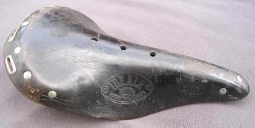
ideale leather saddle
Back in those days it was hard to find bicycle touring gear, or any bicycle gear for that matter. I think my sister or my mom made my panniers from a Frostline Kit. My Peugeot bicycle came with sew-up tires. I ordered an Ideale leather saddle from an actual paper catalog and it eventually appeared in the mail. Plastic bike helmets didn’t exist, and LYCRA was not yet being used for shorts. There were no cell phones and “internet” was not a word. I would stop at a pay phone when I could to call home and let them know where I was and that I was OK. That puts Hemistour in perspective and squarely in the category of extreme sport.

TOSRV West
The Tour of the Swan River Valley, or TOSRV West is a 220 mile, fully supported, two day bike ride that begins in Missoula, goes through Seeley Lake and Swan Lake to Big Fork and returns along Flathead Lake back to Missoula. Two other Hemistour riders, Dan and Lys Burden, were inspired by the Tour of the Scioto River Valley in Ohio and they organized the first TOSRV West in 1971. In the late 1970’s and early 80’s riding TOSRV West was a chance to see some exotic, for the time, bicycles. Of course the high end bikes were all lugged steel with full Campagnolo or Zeus kits. There was even a custom builder in Missoula at the time; Dennis Sparrow, who drove along the route with a van full of tools and worked as the mechanic for the riders. If memory serves, Sparrow was not built like a sparrow. I also remember that he smoked cigarettes which did, and does, seem like an anomaly. Then again Dario Pegoretti wouldn’t strike one as a builder of exquisite bike frames either.

These are some of the memories I will be taking with me to Missoula next month. There is a contingent of riders from Idaho who will be converging on Missoula the middle of July. I’m sure they all have there own reasons for going and will have their own stories and memories from the trip. I intend to collect some of those stories over beers in one of Missoula’s brew pubs. Also looking forward to getting a chance to talk to Greg, June, Dan and Lys.

Categories
Advocacy/Awareness

The Bicycle Threat

 ASLE is an acronym for the Association for the Study of Literature and Environment. Those words together in that order adumbrate concepts beyond the scope of these pages, indeed, concepts beyond the understanding of yours truly. Evan Worthington, who is one of the Boise BLM Wilderness Rangers forwarded to me a draft of a paper presented by Matthew Pangborn at the 2015 ASLE Conference in Moscow, ID. Mr. Pangborn gave permission to Evan to share the paper as he sees fit, so I consider that permission to have accrued to me. The paper presents ideas I have often had but communicates them in ways I never could. In the paper a bicycle becomes a text, is seen as a triviality, then as an annoyance and finally as a threat. Hope you enjoy it and will respond with comments.

(I should have checked with Mr. Pangborn first. Because of the arcane rules of traditional publishing he would not allow me to post this. Trust me though; it was real good.)

Categories
Advocacy/Awareness

Idaho Hot Springs Maps

hot springs and mountains
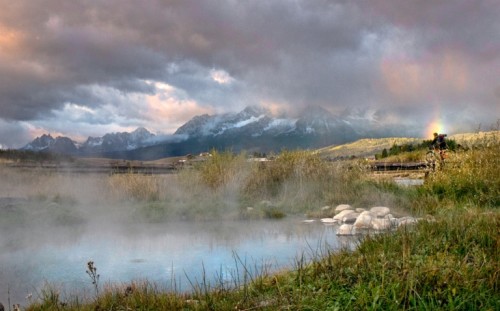
Snakepit Hot Springs, Idaho.
Photo by Casey Greene

Adventure Cycling Association has recently released their Idaho Hot Springs Maps. There are two maps; the Main Route which describes a 517 mile loop beginning and ending in Idaho City and the Single Track Options map which outlines about 227 miles of optional loops off the main route. The main route is divided into a sort of figure eight with the inclusion of the Lowman Cutoff. There is a spur into Boise for those who want to start and/or finish in Boise. Like all Adventure Cycling maps, these are well researched and very detailed with easy to follow cue sheets and descriptions of conditions to be expected. As of this writing we only have one complete set of the maps available in the Bike Touring News store but will be getting more- these have been popular!

Adventure Cycling Association also pioneered the Great Divide Mountain Bike Route which is popular on the bikepacking circuit, and from all the response we’ve seen, the Idaho Hot Springs route is going to be as popular or more so. We’ll try to get some reports from people we know who have done the hot springs route or portions of it. If you have experience with any portion of the route please share it in the comments and/or send us a link if you have an online journal you would like to share.

Categories
Advocacy/Awareness

Don’t Be Left Out.

Last weekend we offered free shipping on all orders placed in the Bike Touring News Store. We also sent out an email blast to local customers about “Fatbike Sunday”. While we sold no fatbikes we did have a pretty good response and some people who were paying attention and came into the store got some really nice prices on accessories. My point is this: you should sign up to be on our mailing list. We send out an auto-responder which is a bi-weekly text email and we send out a newsletter every month or so. In between, we send out notices of special promotions or upcoming events. So sign up to be on the mailing list. You can use the form below or the form in the right sidebar.

Subscribe to our mailing list


Bike Touring News


    If you would like to get updates when there is a new blog post then get the syndicated feed. That too can be accomplished by clicking on the “Syndicate This” link in the right sidebar or by clicking here.
    Thanks for your attention.

    Categories
    Advocacy/Awareness

    Tour De Cure Women’s Bike Series

    Tour De Cure women's series

    We received a call the other day from someone about the Tour De Cure Women Series coming up in Santa Barbara on October 27th.  At first, my thought was why are you calling us, we are in Idaho.  Thankfully the light bulb went on quickly and I was flattered that she recognized Bike Touring News as a way to promote both the ride and awareness of Diabetes.  I think everyone of us knows a diabetic and personally I can’t wait for better treatment options and a cure.  While my Dad doesn’t have diabetes he has the same circulation problems that many diabetics have and treating the open sores on his feet and toes is a constant battle.

    Ride on to support those who can’t.

    So all of you within striking distance of Santa Barbara,  here is the scoop.  Tour De Cure 

    October 27, Santa Barbara, California

    Send us photos and we will post them in our Traveler’s Gallery